
Explore NSF-funded curriculum, teacher supports, research, and resources designed to help students understand complex earth and environmental science topics such as natural phenomena, ecosystems, and human impact on our environment.
- Resources for Teaching & Learning about the Earth & Environment
- What Is Environmental Literacy? | Blog by Karen Hollweg
- Featured Research
- Related Resources
Resources for Teaching & Learning about the Earth & Environment
Resources below are sorted by grade level.
Elementary School
Learning in Places: Field Based Science in Early Childhood Education
Grades: PreK-3
Subjects: Ecology, environmental science, biology, earth science, science education, learning sciences
Learning in Places (LiP) collaborates with PK-3 children, families, educators, and community-based organizations to co-design equitable, culturally based, field-based science education utilizing outdoor places, including gardens. We are working to reimagine how children can engage in seasonal field-based science driven by “should we” questions that cultivate ethical deliberation and decision-making about socio-ecological systems, and that are consequential to children, their families, and their communities.
LiP is guided by what we call the LiP Rhizome. A rhizome is an underground stem that grows horizontally, and it is the main stem of a plant. We use this as a metaphor for the commitments and principles that guide all aspects of LiP. Dimensions of the LiP rhizome include: (a) complex socio-ecological systems, (b) culture, families, and communities, (c) field-based science learning, (d) nature-culture relations, and (e) power and historicity. LiP centers power and historicity and nature-culture relations in place-based science education and by doing so, refuses anti-Blackness, Indigenous erasure, and deficit frames on children, families, and communities. LiP supports learning and being in place that deeply engages children, their families, communities, and educators with learning, wondering, questioning, investigating, deliberating, and decision-making grounded in these various dimensions of the rhizome.
We have also developed three storylines that can be thought of as choreographed learning engagements. All three storylines represent a suggested sequence of bundled activity embedded in a variety of activity systems (classrooms, outdoor spaces, homes and communities) that support learning. Learning in Places has developed a family storyline, a classroom storyline (for educators in schools and also in other learning environments), and a garden storyline. Learning engagements within each storyline contain background information, learning tools, suggested prompts and questions to support learning, connections to LiP-developed educator frameworks and other learning engagements, and ideas for connecting with others to deepen learning. The various tools in the LiP ecosystem are meant to be used together, not in isolation from each other.
Teaching Materials:
- LiP Rhizome
- Educator frameworks around dimensions of the rhizome (updated frameworks and new frameworks will be added to the website as they are developed)
- Storylines:
- Classroom seasonal storyline, with accompanying lessons and family tools *
- Family seasonal storyline: with accompanying materials (Worked example of the family seasonal storyline, with a worked example of the classroom storyline coming soon!)
- Outdoor classroom co-design guide
Learn More: Learning in Places Website | Research Findings | Presentations | Podcast
*The classroom seasonal storyline is aligned with the NGSS. Each lesson plan in every learning engagement contains specific learning goals, connections to disciplinary core ideas, scientific practices, and crosscutting concepts, as well as information about assessment opportunities.
Middle School
 EcoXPT
Grades: 6-8
Subjects: Environmental Science, Ecosystems
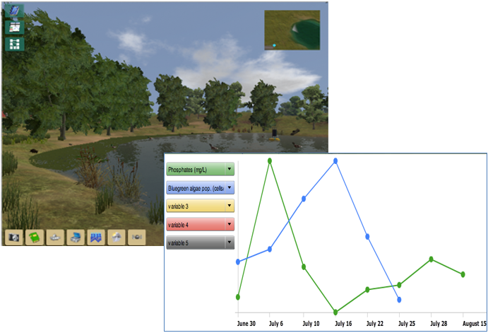
EcoXPT is a three-week middle school curriculum focused on how ecosystems work. Students explore an immersive simulation of a pond ecosystem traveling between different days and locations. Eventually, they discover an environmental puzzle that they attempt to explain by using virtual tools, observing organisms in the world, and by collecting and graphing data. For instance, they can take measurements of water quality, temperature, and population levels of microscopic and macroscopic organisms. Students collect data, graph their findings, and learn from a variety of representations that help them to reason about variables, visible or not, in the world. Students meet virtual ecosystem scientists and use authentic modes of ecosystems experimentation—both in a virtual lab and out in the virtual world. They use an online concept map to make claims, collect evidence, and to offer reasoning in support of their claims as they develop explanations.
Curriculum & Supporting Materials
- Curriculum (create an account to access)
- Teaching EcoXPT During the Coronavirus
Learn more: Project Website | NGSS Alignment | Publications | Presentations | Research Findings
 Life Right Here and Everywhere
Grades: 6-8
Subjects: Ecosystems, Engineering, Environmental Science, Life Science
Life Right Here and Everywhere is an NGSS-aligned curricular unit that is implemented using a learning system called Gooru's Learning Navigator. The system provides opportunities to customize feedback and learning resources tailored to support 3D science and engineering learning specific to each learner. Our learning approach, eco-solutioning, fosters student learning of 3D environmental content through science and engineering practices, e.g., constructing solutions that impact the local environment. The curricular unit concludes with student presentations of their eco-solution plans and prototypes to local stakeholders.
Curriculum & Supporting Materials: Instructional materials, assessment instruments, and student artifacts are in cycle two of iterative development. Final versions of our instructional unit and teacher professional development resources will be available by July 2021 on the project website: lrhe.utah.edu.
Learn more: Project Website | NGSS Alignment | Publications | Presentations | Research Findings
Middle and High School
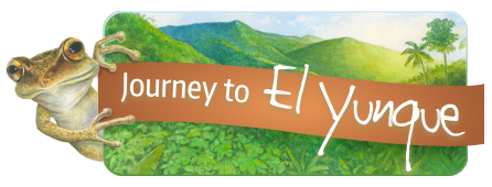
Journey to El Yunque
Grades: 6-8
Subject: Environmental Science
The Journey to El Yunque curriculum introduces students to disturbance ecology, with a focus on both ecosystem resilience and ecosystem change. Each page is beautifully illustrated by Puerto Rican artist Robert Casilla to connect students with Puerto Rican culture as well as help generate curiosity and interest as students move through the curriculum. Students use interactive models to explore how limiting factors, such as the availability of food or shelter, impact the population dynamics of different species following a hurricane. Students figure out that some species are better adapted to post-hurricane rainforest conditions. For example, the fast-growing yagrumo benefits from new canopy gaps created by hurricanes, which allows it to temporarily outcompete slower growing trees. Similarly, the coqui frog benefits from hurricanes because the increase in debris on the forest floor provides additional shelter from predators. While many students initially see hurricanes as threats to rainforests, the exploration of limiting factors and population dynamics helps students understand that hurricanes can temporarily change which organisms are favored for survival, thereby supporting increased biodiversity in the rainforest. Students also figure out that there can be too much of a good thing: if hurricanes become too frequent and too intense, rainforest ecosystems may pass a “tipping point,” leading to irreversible change and a loss of biodiversity. These concepts underlie the intermediate disturbance hypothesis, which is an ecological theory indicating that moderately frequent disturbance events maximize biodiversity within an ecosystem.
Students engage with interactive models of population dynamics that are based on real-world data gathered by our partners at the Luquillo Long-Term Ecological Research program in Puerto Rico. The data from these models serve as evidence for students’ scientific arguments about the impact of hurricanes on specific species in the rainforest. By using these models, students can take on the role of legitimate peripheral participants in the community of practice of rain forest ecology. The models enable students to grapple with complex and cutting-edge questions, and are regularly updated based on new findings in rainforest disturbance ecology. This project is a collaboration among The Learning Partnership, University of Puerto Rico, and Northern Illinois University.
Teaching Materials: Journey to El Yunque Investigations (teacher materials can be requested from demo@elyunque.net)
Learn More: Videos | NGSS Alignment | Publications | Research Findings
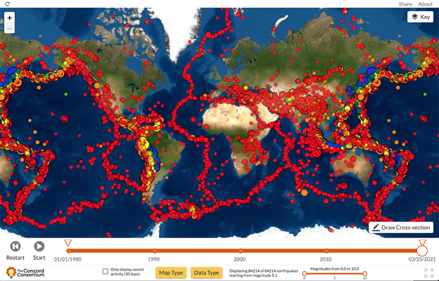 GEODE
GEODE
Grade Levels: 6-12
Subjects: Earth Science, Geology
The Geological Models for Explorations of Dynamic Earth project, also known as GEODE, produced a Plate Tectonics Module that is designed to transform the way middle and high school students learn about plate tectonics. The module focuses on having students investigate patterns of topography, earthquakes and volcanic eruptions and hypothesize how plate motion along boundaries might explain these phenomena. Rather than teaching one boundary at a time, disconnected from other boundaries, the curriculum aims for a more holistic understanding of Earth’s moving plates as a dynamic system. The five-activity module incorporates real-world data, case studies of particular locations on the planet, and the use of two simulations to help students answer the driving question, “What will Earth look like in 500 million years?” The module includes, Seismic Explorer, an easy-to-use data visualization tool that allows students to investigate patterns of earthquakes, volcanic eruptions, and plate motion on Earth. The Tectonic Explorer is a unique 3-dimensional interactive plate tectonics computational model and simulation that helps students explore how the motion of plates in different arrangements can result in a variety of land formations.
Modules, Tools, and Simulations:
- Plate Tectonics Module: The Plate Tectonics module "What will Earth look like in 500 million years?" helps students build a systems view of plate tectonics through focused case studies and interactions with the Seismic Explorer (SE) and Tectonic Explorer (TE) simulations.
- Seismic Explorer. SE is a data visualization tool of real-world earthquake, volcanic eruption, and plate motion data. Students use Seismic Explorer to look for patterns in earthquake and volcanic eruption distribution across Earth’s surface, examine the relationship among earthquake, volcanic eruption, and landform distributions, and explore cross-sections to investigate earthquake depth patterns.
- Tectonic Explorer. TE is a dynamic model of plate interactions on an Earth-like planet. In this web-based three-dimensional simulation of a multi-plate system, students can change the properties of plates such as density, direction of movement, and location of continents. By experimenting with TE, students are able to witness plate interactions on a global level, observe changes over time, and see how interactions of plates result in new landforms.
Related Blog Posts:
- Observe Seismic and Volcanic Activity with Seismic Explorer
- What will Earth look like in 500 million years?
- Exploring Hawai’i (and the rest of Earth) with Seismic Explorer
- The Physics of a Dynamic 3D Plate Tectonics Model
- Geological Models to Help Students Explore the Earth
- Learn Plate Tectonics with an Earth-like model: Introducing Tectonic Explorer
- Teaching Earth and Environmental Science Remotely
- Track Student Work with Class Dashboard
- Teach Plate Tectonics with Tectonic Explorer
- Teaching Earth and Environmental Science Remotely
Learn more: NGSS Alignment | Publications | Research Findings
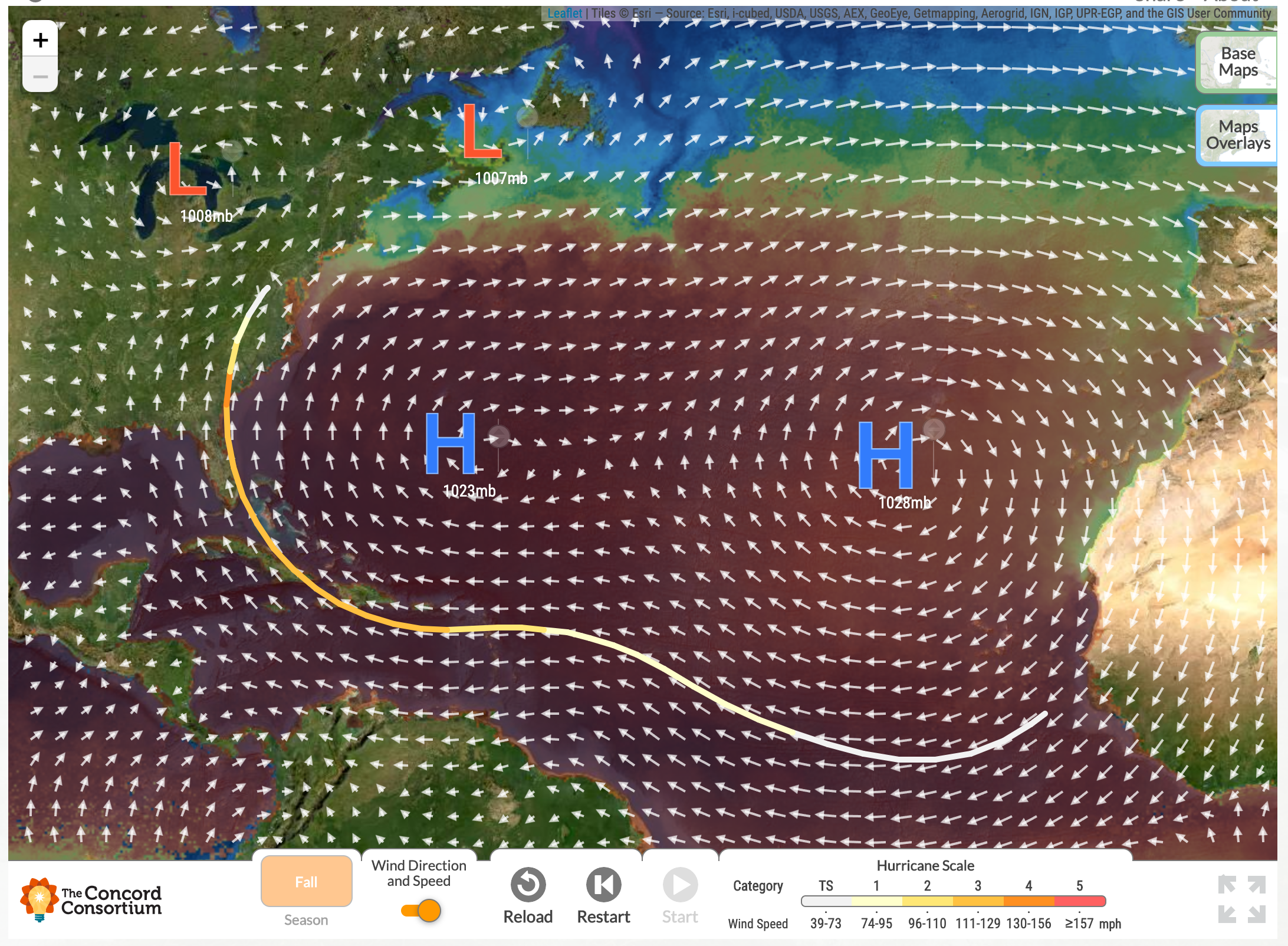
GeoHazard: Modeling Natural Hazards and Assessing Risks
Grades: 5-12
Subjects: Earth Science, Environmental Science
GeoHazard uses Earth system models to help students evaluate natural hazards holistically. Students investigate the factors that influence natural hazard formation, progression, and severity and that contribute the most to potential risks. Throughout the module, students experiment with the initial conditions of the models, run the models to gather evidence, and then reason about the impacts and risk these natural hazards bring. Students also dive into real-world case studies and consider how natural hazards impact people and their communities.
Modules and Tools:
- Hurricane Module: The hurricane curriculum module focuses on the movement and growth of hurricanes. The module includes a model, assessments, and teacher resources.
- Wildfire Model: The Wildfire model is available now. The wildfire curriculum module, focused on wildfire propagation, as well as assessments and teacher resources will be available in summer 2021.
Related Blog Posts:
- Understand Atlantic Hurricane Season with Hurricane Explorer
- Wrangle Uncertainty with the Hurricane Explorer module
- What is Causing all the dangerous wildfires?
Learn more: NGSS Alignment | Publications | Research Findings
Model-Evidence Link Diagrams
 Grades: 6-12
Subjects: Earth & Space Science, Environmental Science
The Model-Evidence Link (MEL) project has developed a set of teaching resources to support the teaching of controversial and/or complex Earth and space science topics, such as fracking and climate change. In MEL activities, students critically analyze multiple models and/or viewpoints and weigh the evidence.
Teaching Resources: All teaching resources and supporting materials can be found on the MEL Project Website.
- Climate Change
- Earthquakes and Fracking
- Wetlands Use
- Formation of the Moon
- Extreme Weather
- Fossils
- Freshwater
- The Origins of the Universe
Build-a-Mel (baMEL) Teaching Resources (students build their own Model-Evidence Link diagram):
Learn More: Project Website | MEL Project Teacher Guide | Professional Development | NGSS Rubric | Publications | Research Findings
High School

Integrating Chemistry and Earth Science (ICE)
PI: Alan Berkowitz
Grades: 9-12
Subjects: Science, Chemistry
ICE is a three-year project funded by the National Science Foundation to develop units for the new Baltimore High School chemistry curriculum that brings earth science into the chemistry curriculum. It includes concepts, datasets and protocols for addressing the question, “How does chemistry shape the physical environment of Baltimore?”
Integrating earth science into high school chemistry can help engage students with compelling local phenomena, especially in districts like Baltimore, MD, that are short on high school Earth Science courses and teachers. In the ICE project, we are developing 3D, NGSS aligned curricula on ocean acidification (in Acids and Bases Unit), urban heat island and energy transfer at local-to-global scales (in Thermochemistry Unit) and the life and death of Baltimore’s mountains (in the culminating Earth Chemistry unit). Students design and carry out investigations in the local urban environment and lab, analyze large datasets from the Baltimore Ecosystem Study and other local science projects, and use conceptual and quantitative models to make sense of the physical science involved in these phenomena.
Learn More: Video | Project Website | NGSS Alignment | Research Findings | Publications & Presentations
Curriculum materials are coming soon!
Related Resources
- Environmental Education | EPA
- Environmental Literacy Framework | NAAEE
- Environmental Literacy Report | NEEF
- Playlist of related DRK-12 videos
- Related Spotlights
- Timeline of Environmental Education History [Interactive] | NAAEE