In this spotlight, eight environmental and Earth Science DRK-12 projects illustrate how the three dimensions identified in the Next Generation Science Standards (NGSS)— Practices, Crosscutting Concepts, and Disciplinary Core Ideas—can be applied to education materials and lesson plans in an integrated way. To highlight a few examples of how the dimensions can be integrated, each project team has chosen one aspect of their work to present in this spotlight.
BIOCOMPLEXITY AND THE HABITABLE PLANET—AN INNOVATIVE CAPSTONE COURSE FOR HIGH SCHOOL
About the project: The Biocomplexity and the Habitable Planet -- An Innovative Capstone Course for High School project has developed, piloted and field-tested Biocomplexity and the habitable planet, a high school capstone course that engages students in understanding biocomplexity, an emerging umbrella science that helps us understand how humans are an integral part of nature, both shaping and shaped by the places they live. The science of biocomplexity integrates core concepts of ecology, biogeography, and the social sciences.
The curriculum consists of inquiry-based investigations designed around cases in urban, agricultural, tropical and polar systems. Since every human action carries consequences for the places they live, students use a range of science tools and ideas to understand the consequences of the choices that humans make about the land, water, and biological communities that we inhabit. The mission of this course is to equip young adults with the knowledge and understanding necessary to make informed decisions in a changing world that confronts them with large and complex environmental challenges.
Project Highlight of NGSS Dimensions: By adopting a biocomplexity approach, each unit in the curriculum addresses NGSS disciplinary core ideas: Ecosystems dynamics, functioning, and resilience (LS2.C) and Human impact on Earth systems (ESS3.C). The scientific cases they build by the end of each unit function as performance assessments 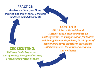 aligned with those described in the NGSS: Design, evaluate, and refine a solution for reducing the impacts of human activities on the environment and biodiversity (LS2-7) and analyze geoscience data to make the claim that one change to Earth’s surface can create feedbacks that cause changes to other Earth’s systems (ESS2-A).
In the Sprawl and Biocomplexity unit students explore the impact of habitat fragmentation on biodiversity as they consider the proposed conversion of farmland to a suburban housing development. They map landscape elements and investigate biodiversity, social factors, fluxes of carbon, the economics of commodity subsidies, and the impact of green design. The students also debate land use alternatives and build a coherent scientific case to support their chosen land use plan for an abandoned farm, which addresses the practice of constructing evidence-based arguments. To understand land use alternatives, the students map landscape elements, addressing the crosscutting concept of patterns and of scale. They also model carbon fluxes, which addresses the crosscutting concepts of systems and systems models, and energy and matter, as well as NGSS core ideas LS1.C Organization for matter and energy flow in organisms and LS2.B Cycles of matter and energy transfer in ecosystems. In the Arctic Biocomplexity unit students engage in NGSS practices as they analyze and interpret data from the primary research literature about the natural history of four important arctic species and build an evidence-based argument. They develop models to project population changes in order to develop a conservation plan that supports viable populations in the face of anthropogenic changes in the Arctic, while taking current and potential future human needs and interactions into account.
Grade Level(s): High School
Products:
- 4 curriculum units with embedded digital resources and accompanying Teacher Guides (coming soon to the Biocomplexity website listed below!):
- Urban Biocomplexity
- Sprawl and Biocomplexity
- Amazonia and Biocomplexity
- Arctic Biocomplexity
- Project Website:http://biocomplexity.terc.edu
CONFRONTING THE CHALLENGES OF CLIMATE LITERACY
About the project: Confronting the Challenges of Climate Literacy (Collaborative Research: Ledley) is an NSF-funded (DRK-12) project that includes curriculum development, teacher professional development, teacher leadership development, and research on student learning—all directed at high school teachers and students. The curriculum unit includes three distinct but related modules: Climate and the Cryosphere; Climate and the Biosphere; and Climate and the Carbon Cycle. These modules add to the growing EarthLabs collection, which includes a teacher resource Web site as well as a student Web site that holds the curriculum units. Themes that cut across all three climate modules include the Earth system, with the complexities of its positive and negative feedback loops; the range of temporal and spatial scales at which climate, weather, and other Earth system processes occur; and the recurring question, “How do we know what we know about Earth’s past and present climate?” which addresses proxy data and scientific instrumentation.
Project Highlight of NGSS Dimensions: Students grapple with the concept of cause and effect in all three EarthLabs modules. Since they do not design complex climate models themselves, they need to formulate their ideas about causal relationships as they study information in the modules, engage in hands-on investigations, analyze data collected by themselves or others, 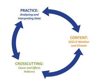 look for patterns, discuss questions with classmates, and ultimately evaluate the evidence, asking themselves: Does this explanation make sense? Am I convinced that “A” directly causes “B”? What mechanism is at play, and how does this process unfold? The relationship between solar energy and climate is an interesting one to examine since it is addressed in different ways in the modules.
In the Cryosphere module, students learn about albedo and the amount of solar energy that Earth absorbs or reflects. They then investigate the mechanism as they collect their own data, using thermometers and a set of Earth materials with various degrees of reflectivity to convince themselves of the relationship between albedo and Earth’s capacity to warm via the absorption of solar energy. Later in the module, the complex, spiral nature of this relationship becomes clear as students study feedback loops in a “connections circle” activity, where they reason that just as the ice causes increased reflection and reduced absorption of solar energy, so too can reduced absorption of solar energy lead to cooling, an increase in ice, and increased reflection of solar energy.
Later in the Cryosphere module students study a graph that reveals a cyclical pattern of warmer and cooler periods on Earth across a period of a million years. What might explain this repeating pattern? Next they explore a set of animations that highlight the periodic shifts in the obliquity of Earth’s axis, variations in the eccentricity of Earth’s orbit, and the precession of Earth’s axis (Milankovitch cycles). Finally they are asked to explore a possible causal relationship between the repeating pattern of Earth’s average temperature and the repeating patterns of the Milankovitch cycles.
Grade Level(s): High School
Products:
- Three curriculum modules and associated teacher resource web sites:
- Climate and the Cryosphere: http://serc.carleton.edu/eslabs/cryosphere/index.html (Student site) http://serc.carleton.edu/earthlabs/cryosphere/index.html (Teacher site)
- Climate and the Biosphere: http://serc.carleton.edu/eslabs/weather/index.html (Student site) http://serc.carleton.edu/earthlabs/weather/index.html (Teacher site)
- Climate and the Carbon Cycle: http://serc.carleton.edu/eslabs/carbon/index.html (Student site) http://serc.carleton.edu/eslabs/carbon/index.html (Teacher site)
- Five teacher-led summer workshops, introducing the new modules to Texas and Mississippi teachers (Two during the summer of 2012; three during the summer of 2013)
- Fifteen teachers who have been prepared to lead workshops for their peers
- Online resources for teachers who lead future workshops (coming soon!)
- Publications or submitted papers resulting from this project:
- Ledley, T.S., N. Haddad, E Bardar, K. Ellins, K. McNeal, J. Libarkin, EarthLabs – An Earth System Science Laboratory Module to Facilitate Teaching About Climate Change, The Earth Scientist, v.28, n.3, p19-24, https://www.nestanet.org/cms/content/publications/tes, September 2012.
- Ledley, TS, E Bardar, N Haddad, EarthLabs – StudentCentered Labs to Engage High School Students, In the Trenches, vol 3, no 3, pages 1-2, July 2013.
- Ellins, K.K, T.S. Ledley, N. Haddad, K. McNeal, A. Gold, S. Lynds, J. Libarkin, EarthLabs: Supporting Teacher Professional Development to Facilitate Effective Teaching of Climate Science, submitted to the Journal of Geoscience Education, June 2013.
- McNeal, K, J.C. Libarkin, T.S. Ledley, E. Bardar, N. Haddad, K. Ellins, S. Dutta, The Role of Research in On-line Curriculum Development: The Case of EarthLabs Climate Change and Earth System Modules, submitted to the Journal of Geoscience Education, June 2013.
ECOMOBILE: BLENDED REAL AND VIRTUAL IMMERSIVE EXPERIENCES FOR LEARNING COMPLEX CAUSALITY AND ECOSYSTEMS SCIENCE
About the project: The EcoMobile: Blended Real and Virtual Immersive Experiences for Learning Complex Causality and Ecosystems Science project combines two curriculum components: 1) a multi-user virtual environment (MUVE) with a scaffolded inquiry experience and; 2) field trip experiences to real environments infused with virtual resources. These complementary experiences were designed to support authentic application of inquiry practices like observation and evidence collection. Students use a two-week inquiry-based curriculum, called EcoMUVE, situated within a virtual world in which students discover and collaboratively explore the ecological mechanisms behind a fish die-off in a virtual pond by using their avatars to collect data, make observations, and build an evidence-based argument to explain the death of the fish. They also use a two-week curriculum, called EcoMOBILE, centered on field trip experiences to real aquatic ecosystems near their school. During this second two-week period, students used smartphones with augmented reality software and note-taking applications, coupled with environmental data collection tools, to compare the real environment to the virtual environment.
Project Highlight of NGSS Dimensions: This project focuses on the Middle School Performance Expectations for understanding “Interdependent Relationships in Ecosystems” including the disciplinary core idea that populations of organisms are dependent on their interactions with the biotic and abiotic components of their environments. A primary focus of the project is helping students to understand the complex causal dynamics inherent to ecosystems and to be able to use these dynamics to interpret and make predictions about the behavior of the ecosystem. It addresses the cross-cutting theme of cause and effect—introducing multiple forms and features of causality, for instance, causes and effects 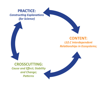 can interact in complex ways and can be separated in space and time. It also engages students in thinking about patterns; particularly in how the numerical relationships within population measures address change over time and possible causal interactions to be explored. The data is observational so students describe likely cause and effect relationships through noticing interactions in the statistical data and by investigating mechanisms that might support the hypothesized relationships. In the process, they learn a lot about stability and change in ecosystems dynamics and of the resilience and functioning of ecosystems.
Specific Science and Engineering Practices support the inquiry in the EcoMOBILE Project. Students learn to ask questions in response to their observations, models that they construct, and unexpected events such as the fish die off in EcoMUVE. They come to realize that they need evidence to support their claims and as they collect real world evidence, they recognize the variation in the measures that comprise evidence. Students ultimately construct explanations for their findings by seeing connections between the quantitative data that they have collected and the qualitative observations that they have made. They then develop models to explain their data and consider whether the data confirms their hypotheses or not.
Grade Level(s): Middle School
Products:
ENHANCED EARTH SYSTEM TEACHING THROUGH REGIONAL AND LOCAL (REAL) EARTH INQUIRY
About the project: Driven by the question, “Why does this place look the way it does?”, the Regional and Local (ReaL) Earth Inquiry Project engages students and their teachers in the close study of Earth systems at the local and regional scale. Program participants create Virtual Fieldwork Experiences (VFEs); representations of actual field sites, first collaboratively at the program’s opening workshop and then closer to home, working with their students. The workshop offers a mentored experience in fieldwork, how to teach in the field and how to use multimedia to make curriculum materials that represent the site. Teachers then return home and make VFEs local to their schools while online collaboration continues. Regionally-focused Teacher Friendly Guides to Geoscience aid in the reading of landscapes’ stories. In the ideal setting, VFE creation is collaboration between teachers and students, meaning that VFEs serve as a catalyst for actual fieldwork. Technology is being used to draw teachers and their students outside to study, document and build understandings of the stories of their local environments.
Project Highlight of NGSS Dimensions: This project is developing a set of approaches and tools that engage learners in the scientific practice of asking questions. Asking questions, beginning with the project’s driving question - Why does this place look the way it does? - leads to the investigation of a 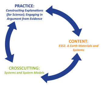 range of disciplinary core ideas, other scientific practices and crosscutting concepts. The project team, in collaboration with participants, have developed a series of supporting questions that may be asked of any field site, which not only facilitates the investigation of these questions and related core ideas, but also highlights a systemic approach to the investigation of environments.
As with all or most of the NGSS’s disciplinary core ideas, most of those in both Earth and space science and in the life sciences play out in some meaningful way outside the classroom door. Amongst the tools we have developed are templates for VFE development with two sets of questions —one for Earth science; and the other for environmental science. Some obvious overlap and interconnections amongst these questions highlight the systemic nature of Earth science as reflected in both disciplinary core idea ESS2.A, Earth materials and systems, and the crosscutting concept of systems and system models.
As students and their teachers create VFEs local to their schools, they must engage in close study of their environment. Using the VFE created by the teachers and project staff offers both a model for what they might create and a point of comparison for building deeper understanding of how their local environment is similar to and different from other sites within their region and around the globe. Students work together to construct explanations of the nature of their environment and we are now working to connect classrooms in different settings so that they might put those explanations to good use, and to defend the evidence behind their explanations.
Grade Level(s): Elementary, Middle and High School
Products:
- Ten cohorts of educators have completed professional development programming that began with a face-to-face workshop within their region and continued after the workshop via online activities. Participants primarily include middle and high school science teachers, but also elementary teachers, college science faculty, National Park Service educators and museum educators.
- Shorter duration professional development opportunities are also planned for the final year of work on the grant, including bringing VFE components to a field trip at the Geological Society of America (GSA) meeting in October, 2013. Information on that programming is here. This is being done in collaboration with education staff at GSA, with the hope that VFEs will be a component of some field trips at all GSA meetings in the future.
- A series of seven regional Teacher Friendly Guides to Geoscience that, when viewed collectively cover the entire US. The Northeast and Southeast Guides are complete and the remaining five guides will be released in the coming months. Available at: http://teacherfriendlyguide.org
- Resources for creating Virtual Fieldwork Experiences are found at http://virtualfieldwork.org. An overview and how-to packet is found here.
- Virtual Fieldwork Experience Database -- a growing collection of VFEs is found within the above website, and may be accessed directly at: http://virtualfieldwork.org/A_VFE_Database.html.
HIGH-ADVENTURE SCIENCE: EARTH'S SYSTEMS AND SUSTAINABILITY
About the project: High-Adventure Science: Earth’s Systems and Sustainability (HAS:ESS)is developing online curriculum modules focused on cutting-edge issues in Earth and Environmental Science. Modules focus on climate change, fresh water availability, energy resource availability, land use, and air pollution. Middle and high school students explore the effects of human resource use on Earth’s systems and how resources can be used in a sustainable manner. The curricula engage students with interactive computational models, analysis of real-world data, and a video of a scientist currently working on the same frontier issues. Students use the models, interpret the data and draw conclusions just as scientists do.
Project Highlight of NGSS Dimensions: High-Adventure Science Earth’s Systems and Sustainability focuses on Next Generation Science Standards (NGSS) Core Ideas: Natural Resources (ESS3.A) and Human Impacts on Earth systems (ESS3.C). The curriculum on Earth’s energy future addresses energy issues with a focus on hydraulic fracturing for natural gas as a way to evaluate risks and benefits, and then has students compare this to other 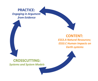 energy sources, including solar, nuclear and wind power. Students explore different sources and uses of energy, particularly how energy resources vary across the world, how energy use has changed over time and how improved technology has changed the way humans use energy. Students learn that there are many ways to generate electricity, each with different risks and benefits to humans, local habitats and the global environmental system.
For each of the topics in HAS:ESS, students must describe the Earth system under study (systems are a NGSS cross-cutting concept). Each computational model helps students to define the system and the various parts of the system, as well as how they interact. Students can change variables and explore the impacts of these changes as shown by the emergent properties in the models.
Additionally, embedded within the HAS:ESS curriculum are explanation-certainty item sets that prompt students to engage in argumentation from evidence (NGSS Practice 7). Making and defending claims are the hallmarks of critical thinking and scientific argumentation skills, but the HAS:ESS curriculum doesn’t stop there. The item sets ask students to answer four separate tasks: make scientific claims; explain their claims based on evidence; express their level of certainty with their explanations; and describe the sources of their certainty. Because the cutting-edge topics addressed in the modules do not have predefined answers, this process helps students to evaluate scientists’ claims—and their own—while considering the level of confidence behind the claims.
Grade Level(s): Middle and High School
Products:
- For information on the High-Adventure Science project, go to the project website:http://concord.org/has
- For publications related to this project: http://concord.org/projects/high-adventure-science#cc1
- To see curriculum modules: http://has.portal.concord.org/ (Modules will be released throughout September 2013.)
OCEAN TRACKS: INVESTIGATING MARINE MIGRATIONS IN A CHANGING OCEAN
About the project: Ocean Tracks: Investigating Marine Migrations in a Changing Oceanis developing a unique model of how to enable student engagement with authentic scientific data via an interactive Web-interface. Ocean Tracks is developing and classroom testing Web-based visualization and analysis tools derived from state-of-the-art knowledge about how to support student inquiry with data. The interface provides access to near-real-time and archival data from electronically tagged marine animals, drifting buoys, and Earth-orbiting satellites. The website features tools that allow students to engage in authentic scientific work with data, developing critical data literacy skills and learning and applying core concepts in ecology, biology, environmental science, earth science, oceanography, and climate science.
Project Highlight of NGSS Dimensions: The Ocean Tracks interface provides tools to allow students to develop skills in the NGSS Practice Analyzing and Interpreting Data. Students pursue questions of current scientific importance using customized versions of the same types of data analysis tools used by scientists. By reducing the cognitive demands typically associated with finding, downloading, viewing data and otherwise learning to use the interface itself, students are able to immediately begin making meaning of the data, drawing inferences and connecting them with evidence.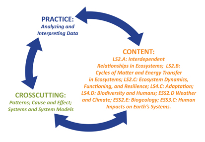 For example, in a simple dropdown menu that includes a range of available tracks, students can select and view the track of an elephant seal. Students can then use an interactive graphing tool to dynamically generate graphs of measurements such as average speed, dive depth and track curviness for selected portions of the track. Based on measurements made using the graphing tool, they could infer that the seal may be feeding along sections where it slows down, dives deeper, and the track becomes curvier. They can explore their ideas and inferences further by superimposing the track on maps of sea surface temperature, chlorophyll concentration, or bathymetry, and by researching the feeding habits of elephant seals in the Ocean Tracks library. Ocean Tracks provides opportunities for students to learn and apply core foundational concepts in biology, environmental science, and earth science, and also to build basic mathematical skills such as graphing and statistical analyses. For example, as students explore scientific questions such as “why is a shark lingering along a sea surface temperature front?” they will need to understand and apply knowledge about the role of predators in ecosystems (Framework LS2.A: Interdependent Relationships in Ecosystems) and interactions between sharks and their physical environment (Framework LS2.B: Cycles of Matter and Energy Transfer in Ecosystems). As they use tracking data to identify areas of importance the tagged species, students can consider the potential long-term impact of changes to the physical environment due to climate change, and will learn and apply concepts related to Frameworks LS2.C: Ecosystem Dynamics, Functioning, and Resilience; LS4.C: Adaptation and LS4D: Biodiversity and Humans; ESS2.D Weather and Climate; ESS2.E: Biogeology; and ESS3.C: Human Impacts on Earth’s Systems. Students also engage in NGSS Cross Cutting Concepts as they compare and look for patterns in the movements of marine animals and seek understanding of cause and effect and system interactions as they attempt to relate these movements to sea surface temperature or bathymetry.
Grade Level(s): High School
Products:
- Web interface tool: http://oceantracks.org
REASONING TOOLS FOR UNDERSTANDING WATER SYSTEMS
About the project: The Reasoning Tools for Understanding Water Systems project is building on learning progression research to study the effects of Tools for Reasoning and Formative Assessments on development of middle school students' understanding of hydrologic systems. The project applies a design-based research approach using cycles of design/revision, teacher workshops, and small-scale classroom pilot tests. The central research question of the project is: How can learning progression-based Reasoning Tools and Formative Assessments support students in using models and representations to engage in principled reasoning about hydrologic systems? This question is addressed through analysis of data from assessments of student learning, student clinical interviews, teacher assessments, classroom observations, and teacher focus groups. The project will contribute insight into developing students' environmental science literacy and reasoning skills needed to make informed decisions about 21st century water issues. Outcomes will include materials for teaching middle school students, strategies for supporting students and teachers in use of the Tools and Formative Assessments, and refinements to the water systems learning progression framework.
Project Highlight of NGSS Dimensions: One scientific practice that is central to the Reasoning Tools project is constructing explanations for science. A core idea in the Water Systems Learning Progression is that traditionally, school science has asked students to develop and repeat understanding of the water cycle that involves naming places water goes and processes involved in that movement (e.g., water falling from a cloud to the ground is called precipitation, 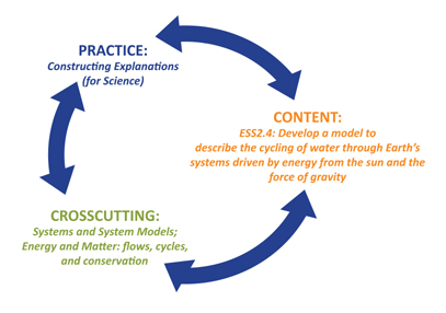 water moving from Earth’s surface to the air is called evaporation). These are descriptions rather than explanations. Explanations involve explaining how and why things happen. In the water systems project, the focus is on explaining driving forces (e.g., gravity, thermal energy, pressure) and constraining factors (e.g., topography, elevation, permeability, etc.) that govern how and why water moves through connected natural and human engineered systems.
In asking students to provide explanations of driving forces and constraining factors for water moving through connected hydrologic systems, the project also addresses core disciplinary ideas from the Next Generation Science Standards (e.g., MS-ESS2-4: Develop a model to describe the cycling of water through Earth’s systems driven by energy from the sun and the force of gravity). Crosscutting concepts of systems and system models and energy and matter: flows, cycles, and conservationare also addressed as students trace water through connected hydrologic systems, focusing on what drives and constrains water movement.
The products that our project has developed, including the learning progression framework, Tools for Reasoning, Formative Assessments, instructional activities, and supporting materials for teachers, are designed to work together to help middle school teachers and students develop facility with teaching and learning the scientific practices, core disciplinary ideas, and crosscutting concepts identified above.
Grade Level(s): Middle School
Products:
- Water Systems Learning Progression Framework Description: https://www.umt.edu/watertools/learning_progression.aspx
- Gunckel, K., Covitt, B., Salinas, I., & Anderson, C. 2012. A Learning Progression for Water in Socio-Ecological Systems. Journal of Research in Science Teaching, 49(7), 843-868. doi: 10.1002/tea.21024
- Water Systems Tools for Reasoning: https://www.umt.edu/watertools/teaching_materials/default.aspx
- Formative Assessments with Student and Teacher Materials: https://www.umt.edu/watertools/teaching_materials/default.aspx
- Learning Progression-Based Lessons and Activities with Supporting Materials for Teachers: https://www.umt.edu/watertools/teaching_materials/default.aspx
STUDYING TOPOGRAPHY, OROGRAPHIC RAINFALL, AND ECOSYSTEMS (STORE) WITH GEOSPATIAL INFORMATION TECHNOLOGY
About the project: The Studying Topography, Orographic Rainfall, and Ecosystems (STORE) with Geospatial Information Technology project provides climatological and vegetation data about “study areas” in California and New York State plus geospatially distributed projected values of temperature, precipitation, and land cover in 2050 and 2099, derived from NCAR’s A2 climate change model. There are also data about summer and winter storm events in the study areas that students can analyze to differentiate weather and climate characteristics. Students use Google Earth and ARC GIS Explorer Desktop to study changes in recent 30-year average precipitation and air temperature data at weather stations along transects within the areas. Lessons direct them to create tables noting the changes against varying elevation, thereby reinforcing understanding of orographic effects in the water cycle. The data are made available to the public by the National Climate Data Center (NCDC), as part of the Global Historical Climate Network (GHCN). A core curriculum consisting of six lessons exists that teachers can use as is or adapt based on what curriculum needs they have for the particular courses and students they are teaching (e.g. Earth science, environmental science, biology).
Project Highlight of NGSS Dimensions: STORE has developed an interactive geospatial technology-based data viewing tool and curriculum that addresses the core idea of Weather and Climate. Students use real geospatial data sets to study 30-year climatology averages of temperature and precipitation. These activities address the NGSS scientific practice of analyzing and interpreting data. In addition, the students look at the climate pattern over a 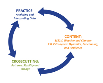 diverse geographical “study” area, which addresses the crosscutting concept of patterns. They also compare the climate model data for projected temperature and precipitation averages in the years 2050 and 2099 to the climatology averages to see what the projected impacts are of climate change if current rates of carbon emissions continue unabated. In the process they see whether projected model-derived values show the same orographic effects relative to proximity to the ocean. In these lines of inquiry, students are given the opportunity to consider how change in rates over time can be quantified and modeled, a component of the NGSS high school crosscutting theme stability and change. The curriculum also crosses into biology by having students examine data from a recent survey of predominating vegetation within the study areas and projected changes in their tolerance ranges. These projections result from applying highest average daily July temperatures from the climatology to the projected values from the climate model. In observing what would be the projected tolerance ranges of deciduous and evergreen forests in particular using only these temperature projections, students consider critically whether other data might be welcome for making a more accurate assessment, such as the species’ gene pool and migratory characteristics. In this way, the curriculum also aligns with NGSS’s core idea Ecosystem Dynamics, Functioning, and Resilience. The lessons were intended for high school but middle school teachers and community college instructors are also using and adapting them.
Grade Level(s): Middle and High School
Products:
- Visit the project website at http://store.sri.com to view:
- LESSONS: technology-heavy and technology-light versions of six project-developed lesson plans
- DATA: master files containing geological and climate data
- RESOURCES: resources including background information about the data, the climate model, and the data layers, so that teachers and students understand what they are analyzing; narratives about the climates in the two study area states, New York and California; content representation forms and assessment instruments for teachers; instructional videos about how to use the STORE data in Google Earth; and reports, papers and presentations about the project.
- Poster presented at the 2012 AERA Meeting